Subscribe
to receive news by email

Poll
Will the Trump Administration Shift U.S. Policy in Favor of Palestine?
- No (87%)
- Yes (13%)
Copyright © 2026 Arab America
Go topThrough Syria's Valley of History

By: Habeeb Salloum/Arab America Contributing Writer
Less than half an hour after leaving Aleppo behind, we turned westward at Saraqab, a rich northern Syrian farming town. In a few minutes we were driving through a countryside filled with countless well-laid orchards, many planted during the last decade.
In the Greek/Roman era this part of Syria was noted for its flourishing towns and cities – one of the richest farming areas in the civilized world. However, in the ensuing centuries, wars and soil erosion depopulated the land and the urban centres became ghost towns. It has been only in the last few years that the rocky landscape has been revitalized. Endless fruit orchards have, to some extent, returned the former wealth to this northwestern corner of the Fertile Crescent.
Our route took us through a gentle rolling land whose red soil contrasted vividly with the green of the olive, plum, pomegranate and, above all, innumerable cherry trees. Their flowers in hundreds of colours pointed to a season of plenty. This year the people of Syria would be content with their fruit harvest. The souks will overflow, and prices will not rise. Almost all of the country’s fruit and olive requirements are met from the seven million fruit tree in this delightful corner of an ancient land.
A few miles after departing from the rapidly developing town of Idlib with its wide landscaped streets, we stopped on a mountain top overlooking the northern rim of the Orontes River depression below. The valley floor was a checkerboard of glistening green yellow and red. To the east, edging this lush landscape, known as the Ghab, were the lower parts of the hills, on top of which we stood green with fruit trees. The scenic plains and flowering hills were a kaleidoscope of vivid colours.

Through this valley, from the dawn of history, men have come to conquer or retreated in defeat. However, today, from being a pathway for invading armies, it has become Syria’s valley of the future.
For thousands of years the Ghab through which the Orontes River made its way northward was an unhealthy malaria-filled marshland. In the 1960s and 70s, these swamps were drained, and a series of canals were built. The former water-logged land became the richest part of Syria, yielding many types of fruits, grains and vegetables. Hemmed on the west by the Ansariyah coastal mountains and on the east by the Zaouiye range, these rich irrigated plains are today the breadbasket of Syria.
We crossed the green valley floor driving toward Jisr Ash-Shugur, midway between Syria’s northern capital of Aleppo and Latakia its chief seaport. Passing a newly built huge sugar refinery, we entered the outskirts of the town. As we neared the heart of this farming centre, its scenic character became evident. The town was built on a terraced hill crowned with a ruined fort. White, blue and green plastered houses crowded the terraces imprinting on this small city a unique appearance.
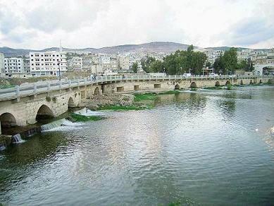
Situated on the northern rim of the Ghab, Jisr Ash-Shugur is the rail and road transport centre of the valley. From here by truck or on a newly built railway, the produce of the plains is shipped to all parts of Syria and beyond.
Our stop was short, only several minutes for refreshments. The ruins of Apamea where Antony and Cleopatra once dallied beckoned. Southward, the highway, bordered with green irrigated fields, ran along the western edge of the Ghab. Tractors drawing wagons carrying brightly dressed working men and women waving and smiling as we passed clogged the road. It appeared that both the fertile fields and their tillers had a buoyant air.
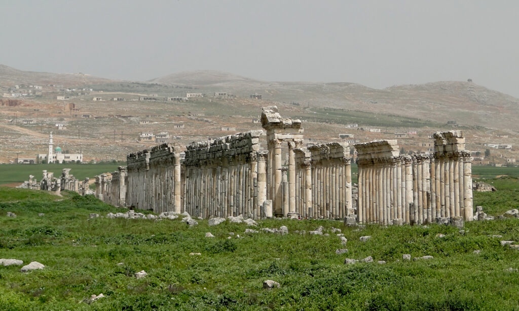
In less than an hour of leisurely driving we halted at a khan – one of the best preserved caravanserais in Syria. Now restored and made into a museum, it is located in the shadow of Qal’at al-Mudiq (Citadel of the Defile) – an impressive Arab hilltop fortress. Viewed from below, this majestic brownish castle with massive towers rising from high cliffs is a postcard picture of a medieval stronghold. We drove to the castle from the north on a narrow road winding its way to the citadel. Inside, the fortress is crammed with half-abandoned streets and rundown houses – a letdown from its storybook appearance seen from the distance. However, its ramparts offer an excellent view of the green valley and the ravine which gave the fortress its name. To the east, below the walls of this stronghold, important during the Crusades, lie the vestiges of the Greco/Roman city of Apamea – once a metropolis of 120,000 souls.
This once famous urban centre was established in 300 B.C. by one of Alexander the Great’s successors, Seleucus, and named after his wife Apamea. In its days of glory, it was one of the richest towns in the Roman Empire and in war could field 600 war elephants. In the Greek and Roman eras, it was renowned for its philosopher sons and later in the Christian epoch it became the centre of monophostism – the doctrine denying the duality of Christ.
A number of Roman dignitaries and emperors visited the city when it was under the sway of Rome, the most celebrated being Antony and Cleopatra. Here they rested and enjoyed themselves after returning from their wars in the East.
In the subsequent centuries the city declined until it was demolished by two earthquakes in 1157 and 1170 A.D. The site was forgotten until 1930 when excavations, which are still continuing, were begun by Belgian archaeologists. However, these have barely revealed the secrets of that once thriving city.
Today, the uncovered parts of the ruins are a gigantic litter of stone building blocks. Spread out in all directions are parts of Apamea’s former edifices which were enclosed within seven kilometres of walls. A jumble of cut stone construction blocks intermixed with huge broken capitals and columns, the ruins are a man-made lunar sight.
The chaotic spectacle is, somewhat, put into order by a series of re-erected fluted columns with their capitals. Nevertheless, these are only a few of the many hundreds which once lined the 1,850-metre-long and 37-metre-wide main thoroughfare of the city. Yet, just to view alone the lofty standing pillars with their twisted fluting and Corinthian capitals would justify a visit to this pile of broken man-made rocks.
In addition to these columns, other remains of structures which still can be identified are worth a fleeting visit. The traces of the governor’s palace with parts of its mosaic floors; the Roman Temple of Fortune; the agora; a number of churches; and the theatre would be of interest to a tourist enthralled with the Greco/Roma age. Although not much of these structures still stand, on e with imagination can picture them as they once were.
The few relics which the traveller sees today are only a small part of what the ruins will one day offer. Vast areas are still covered with earth which has hidden Apamea’s treasures for centuries. Hence, the future of these tumbled remnants, scattered as far as the eye can see, is bright. Open to the winds, today they impart a poetic message. Tomorrow uncovered and partially restored, they will give an insight into history.
From the ruins of Apamea we travelled southward, through a luxuriant land criss-crossed with irrigation canals. Heavily laden lorries lumbered past, mostly northward, carrying farm products to Jisr Ash-Shughur. The drivers and other passersby shouted greetings – a common Arab trait of hospitality found all across the Syrian countryside.
It was noon when we beheld looming in the distance the medieval castle of Masyaf. As we neared, we could see that this magnificent fortress dominated the small market town carrying its name. Its majesty was a breathtaking sight. Houses clustered on the lower side of a hill ended below a natural slope of rock. This led upward to the lower walls of an Ayyubid type fortress. Rising half-ruined amidst its encircling ramparts with towers open to the sky, it is a spectacle of medieval wonder.
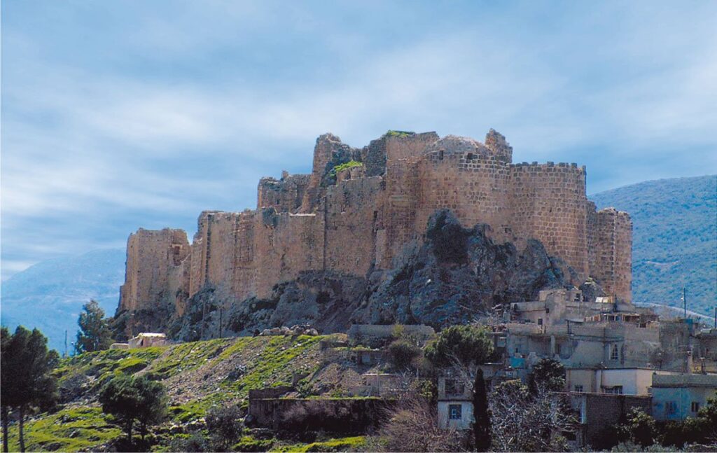
The best-preserved section of the citadel is the entrance fortifications, the only portion of the stronghold worth examining. Most other parts await the hands of the renovators. However, the view from the castle walls of the surrounding orchards and fields is in itself worthy of a visit. Built on the edge of the Ansariyah mountains like a sentinel guarding the plains below, it is a fairy tale stronghold that inspires poets.
In the medieval period Masyaf was the headquarters of the Hashshashīn (Assassins) – a fanatical religious sect. From here, their leader the famous ‘Old Man of the Mountain’ harassed for 50 years both Arab and Crusader alike. Today, the citadel is not visited for its architectural detail or the beauty of its setting. Rather, travellers come curious to view the place where once this redoubtable chief of the mountain struck terror in the hearts of generals and kings.
From Masyaf we travelled westward on the attractive Baniyas road. Skirting deep ravines, the road snaked upward to the desolate heights of the Ansariyah Mountains. Now dotted with peaceful villages, the higher ridges of these inaccessible mountains were once the fortified strongholds of Rashīd al-Dīn Sinān (the Old Man of the Mountain) who gave the English language the word assassin.
We drove through the lower wooded Ansariyah slopes, then passed though citrus orchards as we skirted Baniyas on the edge of the blue Mediterranean. Northward we travelled through endless fields bursting with lemon and orange trees until we reached Latakia – our goal for the night.
As we enjoyed our evening meal in a charming hotel overlooking the city’s beautiful beaches, we reminisced about Syria’s valley of history. Apamea with its lovers Antony and Cleopatra and Masyaf with its fanatical Assassins was now only an exciting memory.
Check out Arab America’s blog here!