Subscribe
to receive news by email

Poll
Will the Trump Administration Shift U.S. Policy in Favor of Palestine?
- No (86%)
- Yes (14%)
Copyright © 2026 Arab America
Go topArab Contributions To Geography And Navigation
The world’s earliest geographical and navigational charts were developed by Canaanites who, probably simultaneously with the Egyptians, discovered the Atlantic Ocean. Later, the Greeks speculated on the idea that the earth was round. Subsequently, the Arabs improved on this earlier knowledge in the fields of the armillary sphere, perfected the calendar, making it more accurate than the Gregorian, and invented or evolved older instruments to facilitate sailing the seas and trading with other countries in the known world of the time.
What helped the Arabs immensely in sailing the seas was their study of the winds. In the Indian Ocean, they discovered that the monsoon winds blew toward India in the summer and Africa in winter. Subsequently, these Indian Ocean winds were to play a vital role in sailing to the shores of East Africa as far as Madagascar, and past the Indian sub-continent to the Indonesian archipelago and China.
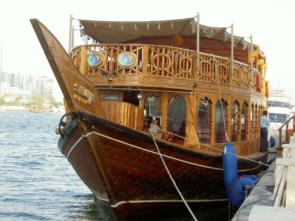
The dhow traders were the link between the Orient and the Arab East through which the silks and spices of the East found their way to Europe. On this commerce, the medieval city states of Italy flourished and as a result of these trading activities, the medieval Arab navigators and geographers mapped the known world of their times and anticipated Columbus in venturing into the Atlantic as far the Azores.
Using information gained from travelers, sailors, scholars, caravans, travelers, and ancient sea traders – the Arabs had been trading with China for more than a thousand years – many books were written in Arabic about geography, navigation, and travel. The legendary tale of Sindbad the Sailor was a highly exaggerated story of travel during that age.
To make travel and trade easier and more wide-ranging, they improved upon ancient navigational practices with the enhancement of the quadrant, sextant, and the astrolabe, a Greek invention, without which, before the compass, navigation was almost impossible. When describing this medieval instrument, the Middle East International Journal in its December 1975 edition quotes C. Waddy in, The Wise Men and the Stars, who writes:
“The astrolabe combined something of the nature of a sundial with maps of the stars and the planets. A sophisticated model could answer a thousand mathematical problems – not a bad computer for the Middle Ages. It was the mother of all the later instruments for measuring the stars, and was first developed by Greeks in Alexandria, perfected by Arab and Persian astronomers, and introduced by them to Europe. For more than a thousand years the astrolabe was paramount. It could tell the times of sunrise and sunset, darkness and dawn, for any day of the year. It could give the compass bearings of stars, moon, and planets at any particular time. It could measure the height of a house or a mountain. Portable models might be only two or three inches across and, in the days before clocks, could tell time.”
The astrolabe migrated with Islam through North Africa into Spain where it was introduced to Christian Europe through monasteries in northern Spain and came into widespread use in the 13th and 14th centuries. In that same period, there were at least a half dozen competent astrolabe treatises in Latin. Subsequently, the Europeans extended the plate engravings to include astrological information and adapted the various timekeeping variations used in that era.
Equally as important was the development, in the 9th century of the magnetic needle. Although the Arabs were not forerunners in discovering the magnetic quality, attributable to the Chinese and the Greeks, they were the first to exploit this invention in making the initial compass a device for deciding directions with a needle that points to the magnetic north. The Chinese are said to have been the first to create the magnetic needle, but the Arabs were the first to use it for navigation.
German researcher, Sijreen Honkeh, confirms that the compass was transferred into Europe through two channels, firstly by way of the Muslim seafarers during the Crusader wars and secondly, in the 15th century, via the Muslim sailors from southern Asia who were employed by the Spanish and Italians.
In their golden age, even though some Arab geographers accepted fables and legends as facts, unlike their Western medieval brethren, Arab scientists did not believe that the earth was flat but, rather, had a circular shape. However, they were often impressed by seemingly unscientific geographical theories.
One of these wild assumptions was that of the ‘cupola of Arin’, situated supposedly at the center of the world and located in India. The idea was adopted by western scholars and found its way to Cardinal Peter of Ailly’s book, Imago Mundi, published in 1410. Formulating his ideas based on this work, Columbus assumed that the world was shaped like a pear and there had to be another center for which he went searching to the west.
Through the centuries of Arab technical superiority, a great many Arab sailors and travelers wrote about travel and the sea. From among the many, the first was a Sulayman al-Tajir, an Arab seaman, in the 9th century, who sailed from Siraf, a port in the Arabian (Persian) Gulf, across the Indian Ocean to China. He wrote an account of this journey, Akhbar al-Sin wa al-Hind (The News of China and India), which was only completed some years later by a compatriot, Abi Zayid Hasan al-Sirafi. His book is the first-ever published in the West about the customs of the Indians and Chinese.
Abul Hasan Ali al-Mascudi (888 – 957) was born in Baghdad and is known as the ‘Herodotus of the Arabs’ because he was the first Arab to combine history and scientific geography in a large-scale work. He traveled extensively throughout India, the Middle East, and Africa and wrote a historic-geographical encyclopedia of 30 volumes relating to the history of the world and his travels. In his book, Muruj al-Dhahab wa Macadin al-Jawahar (The Golden Meadows), he recounts his 25 years of travels throughout the Muslim lands and the bordering states. He talks about the sea, seamen, and their language and provides geographical and other information, especially historical anecdotes, based on earlier authorities and personal experience.
Al-Mascudi, was also a historian and he wrote on the process of evolution. In his works, he speaks of the process of transformation from mineral to plant, plant to animal, then animal to man. It is recognized by many scholars that al-Mascudi’s 10th-century theories of evolution could easily be the forerunner of the Darwinism of the 19th century.
In 921, the Caliph al-Muqtadir of Baghdad sent Ibn Fadlan with an embassy to the Bulgarian king of the Middle Volga. Ibn Fadlan wrote an account of his journeys called Risala which became a great historical work in that it gave the earliest trustworthy account of Bulgaria and Russia. Even though some inaccuracies and personal prejudices creep into Ibn Fadlan’s book, it is still, nevertheless, a fine geographical work for that era.
Countless other Arabs wrote about geography, the sea, and travel. However, for the western world, overshadowing these historical figures was one of the most brilliant geographers of the medieval world, al-Idrisi. A renowned 12th-century Arab geographer, he was born in Morocco and invited by the Norman King, Roger II, to live in Sicily. Surpassing all the geographers in his time, Idrisi was commissioned by the king to build a silver globe and compile a world atlas. Called Kitab al-Rujari (Roger’s Book), Idrisi’s work was considered the best and most accurate geographical guide to the world in medieval times.
It included information relating to both Christian and Muslim countries and included 70 maps, some of which define areas in the world never previously chartered, as well as the inclusion of the source of the Nile in Uganda. It is ironic and ever so much more apparent that having never read Idrisi’s work, Englishmen, in the 19th century, were still searching for the source of this river.
The 14th-century ibn Battuta was born in Tangier and set out on his first journey to perform the pilgrimage to Mecca. The pilgrimage became the first part of a journey that was to take him across half the world and last nearly three decades, making him the greatest and hardiest traveler of his time. He was not a professional geographer, but in his travels by horse, camel, and sailboat, he covered over seventy-five thousand miles. His wanderings took him to most of the Arab world, Turkey, Bulgaria, Russia, Persia, India, Central Asia, the Far East, and East and West Africa.
He spent several years in India, and from there was appointed ambassador to the Emperor of China. After China, he returned home, then toured Spain and many places in West Africa. Ibn Battuta’s book, Al-Rihla (The Journey), which he spent almost 23 years of his later life writing, is filled with information on the administration, politics, religious leaders and saints, social conditions, and the economics of the places he visited. It is one of the most comprehensive and entertaining travel books ever written.
Unlike most other Muslim travelers, he gives the reader an insight into the life of women in the countries that he toured. As was the custom of the day and being enamored by the fair sex, he married a number of times during his wanderings. All this and much more is included in his travel book – a truly monumental work of the countries of the world in his era.
Hassan al-Wazzan (1495 – 1550), known as Leo Africanus in the West, was a twenty-five-year-old Arab, captured by Italian pirates in 1520. Born in Granada of Moorish parents and educated in Morocco, he set out at an early age to travel in Africa. By the time of his capture, he had become the greatest expert on Africa.
Because of his fine qualities, he became a protégé of Pope Leo X, a scion of the great Medici family – the famous patrons of Michelangelo and Raphael, who persuaded the young man to become a Christian, gave him his own name – the name by which the Western world would know him. Later, the Pope convinced him to write an account of his travels about the then almost unknown black continent, after which, he received much attention in the West. Leo Africanus himself translated into Italian the story of his African travels. Later, his story was translated into several European languages and for nearly two hundred years, it was read as the most authoritative source on Africa.
After the establishment of the Arab/Islamic Empire, trade flourished throughout the Muslim world and beyond. Shortly thereafter, there came into being a highly developed banking system with branches in all the large cities of the Muslim lands. Trade barriers such as duties and taxes were very few. A variety of banking practices such as checks and letters of credit became very common. This meant that a merchant in faraway al-Andalus could draw money from any city, no matter what distance from that far-western Arab country.
Hence, never before in any other civilization or empire did people, spread over a large distance, have such a broad range of products available. During its golden age, the Muslim Empire functioned like a modern free trade area. The standard of living rose throughout the empire and there came, into being a large affluent class. Some of this wealth spilled over into Europe and, along with the scientific knowledge the Arabs passed on to Europe, helped to fuel the continent’s renaissance.
In the 15th century, Price Henry the Navigator used skilled Arab navigators to train his pilots, setting Portugal on its way to becoming a world maritime power. In the same century Vasco da Gama while exploring the east coast of Africa near Malindi, was guided by an Arab pilot, Ahmed ibn Majid, who used maps never before seen by Europeans.
Ibn Majid later guided Vasco da Gama, some historians say by force, to India – opening this important route to Western seafarers and the ‘Age of Discovery’. With this last captain of the sea, Arab navigational skills passed on to others, but before this happened, they had contributed much to world geography, navigation and trade.